


Solages - Labaudie

Frayssinet
User
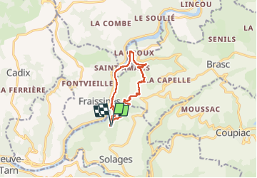

Length
10.1 km

Max alt
526 m

Uphill gradient
382 m
Km-Effort
15.2 km

Min alt
218 m

Downhill gradient
389 m
Boucle
Yes
Creation date :
2024-04-28 06:57:20.626
Updated on :
2024-05-07 15:02:06.065
3h27
Difficulty : Difficult

FREE GPS app for hiking
 SityTrail
IGN / Geographical institutes
SityTrail Plus
The world is yours!
About
Trail Walking of 10.1 km to be discovered at Occitania, Aveyron, La Bastide-Solages. This trail is proposed by Frayssinet.
Description
Face à Fraissines et Combradet.
Attention: Bartassage le log du tarn.
Positioning
Country:
France
Region :
Occitania
Department/Province :
Aveyron
Municipality :
La Bastide-Solages
Location:
Unknown
Start:(Dec)
Start:(UTM)
461614 ; 4867176 (31T) N.
Comments